
The Victorian Government has announced it will invest more than $35.2 million to develop its first state-wide ‘digital twin’ – a virtual replica of Victoria.
The Government will partner with the CSIRO to develop the data-rich online platform, which it expects to launch by end of this year.
Victorian Minister for Planning, Richard Wynne, said the new digital twin would transform planning, supporting an infrastructure-led recovery throughout the state.
“Digital Twin Victoria will catapult Victoria into its digital future, driving efficiencies in planning and construction to supercharge the state’s long-term growth and continued economic recovery,” Wynne said in a statement.
Digital twins provide virtual representations of real-world objects, structures or areas – in this case, including “bricks and mortar [buildings], utilities infrastructure, farmland or cities”. These twins can also be programmed to deliver updates, including traffic flow and building works, in real-time.
“Once this platform is established”, Wynne said, “real-time data can be collected at an astonishing rate and absorbed into the Digital Twin to support informed planning decisions and share important information with communities.”
“Planners, engineers and builders will be able to use Digital Twin Victoria to model different project scenarios, test the feasibility of proposals, troubleshoot potential issues, and share complex information across sectors and workplaces more easily.”
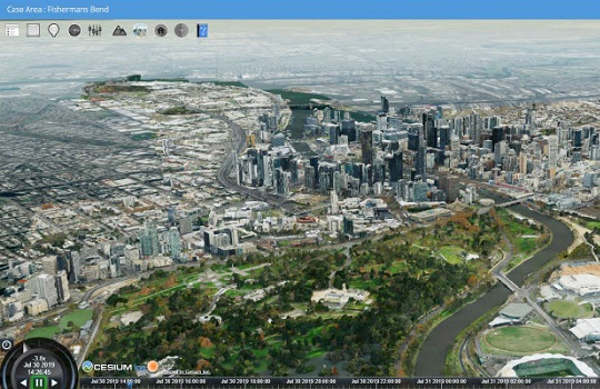
The Digital Twin Victoria builds on a proof-of-concept (PoC), announced by the Victorian Government in 2019, to create a dedicated digital twin for the Fishermans Bend area – a 480-hectare locality in central Melbourne, promoted as Australia’s largest urban renewal project.
The Fishermans Bend digital twin was developed on a cloud-based geospatial platform, adopting FAIR (Findable, Accessible, Interoperable, Reusable) data principles.
The platform supports 4D (3D, plus time) modelling of a physical asset’s design and condition (above and underground), and includes precise location and legal boundaries.
Development of the original Fishermans Bend platform could also foresee the rollout of advanced tracking and predictive capabilities, including traffic flow predictions, power and water usage, and shadow analysis.
During its development, the developers of the PoC revealed a number of barriers to advancing the digital twin project, including a lack of available and relevant data as well as governance and organisational cultures that were stymieing data sharing.
However, the Government acknowledged strong national collaboration and stakeholder engagement in the PoC.
In its own digital twin development, the NSW Government earlier this year revealed it would also seek to expand its Western Sydney-based spatial twin to incorporate the entire state.
The Department of Customer Service, NSW Spatial Services, revealed it is seeking to develop a business case to enable the state-wide rollout of the existing digital twin. The current proof-of-concept, which debuted in February last year, covers just eight LGAs in the Western Sydney region, including the Western Parkland City, Greater Parramatta and the Olympic Peninsula.
The 4D (including time) model provides a virtual representation of infrastructure, including buildings, strata plans, terrain, property boundaries and utilities, which can also be overlaid with live feeds of real-time data.